Thursday, January 12, 2006

New book: A Science on the Scales


A Science on the Scales: The Rise of Canadian Atlantic Fisheries Biology, 1898-1939. Author: Jennifer M. Hubbard

If my memory does not fail me Jennifer presented her research at BIO a few years ago. The book will be available in Chapters soon.

Cayman Islands Seabed Mapping under Bimini Tops


The Cayman Islands will soon have new and updated maps of the seabed that surrounds it thanks to a new hydrographic survey project being undertaken by the Lands and Survey Department. One of the key pieces of equipment in the survey is a new, specially equipped boat which will be launched on 19 January. This first–of–its–kind project in the Cayman Islands is funded by the Portfolio of Internal and External Affairs.

The vessel, The Aliceann, is a 28–foot Merpanga boat. Over a six–month period it will methodically travel from 300ft beyond the “drop off” around the island to the shore, and take readings to show the contours and features of the ocean floor around the entire island.

The www.caymanpass.com did not give any details on acoustic system to be used, but mentioned that the boat will be equipped with extended Bimini top to provide cover at the front of the boat where the surveyor will work. Probably the surveys will go like this ;-)

Investing in Ocean Treasure Hunters: Odyssey Marine Exploration


Company profile (from Yahoo Finance):
Odyssey Marine Exploration, Inc. engages in the exploration and recovery of archaeologically-sensitive deep water shipwrecks worldwide. Its active projects include SS Republic, HMS Sussex, the Concepcion, the Seattle, and the Blue China. The SS Republic, a sidewheel steamer lost in deep water in 1865. The company engages in the location, recovery, conservation, and marketing of artifacts and cargo from colonial-period British warship, HMS Sussex, which was lost in a storm in 1694; the Concepcion, a shipwreck that sank during the early eighteenth century; and the Seattle, a steam ship that sank after the Civil War. The Seattle’s cargo included approximately 48,000 troy ounces of gold. The Blue China wreck, which was discovered during Odyssey's 2003 SS Republic project search operations. The site is believed to be a merchant ship from the late 1700's or early 1800's carrying trade goods. Odyssey Marine is headquartered in Tampa, Florida.

Ticker - AMEX: OMR

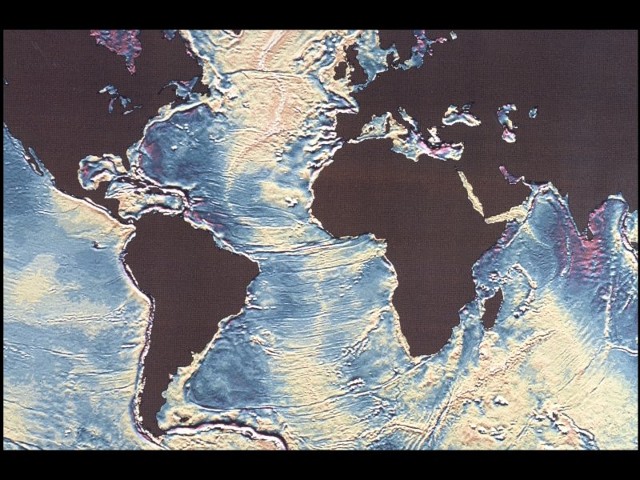
William Haxby dies at 56

William F. Haxby, who created the first maps of the ocean floor to be based on satellite measurements of the water's surface and became a master at translating complicated marine data into comprehensible visual displays, died on Wednesday at his home in Westwood, N.J. of heart attack. He was 56. Dr. Haxby, a research scientist at the Lamont-Doherty Earth Observatory at Columbia University since 1978, used measurements of the height of the sea surface from Seasat satellites and other sensors to produce first global "gravity field" map of the world's oceans (in 1983).
NY Times.